Accessing and Visualizing Esri GeoServices with ArcGIS API for JavaScript, D3, and Node.js
Mike Juniper :: Washington DC R&D Center
github.com/chelm
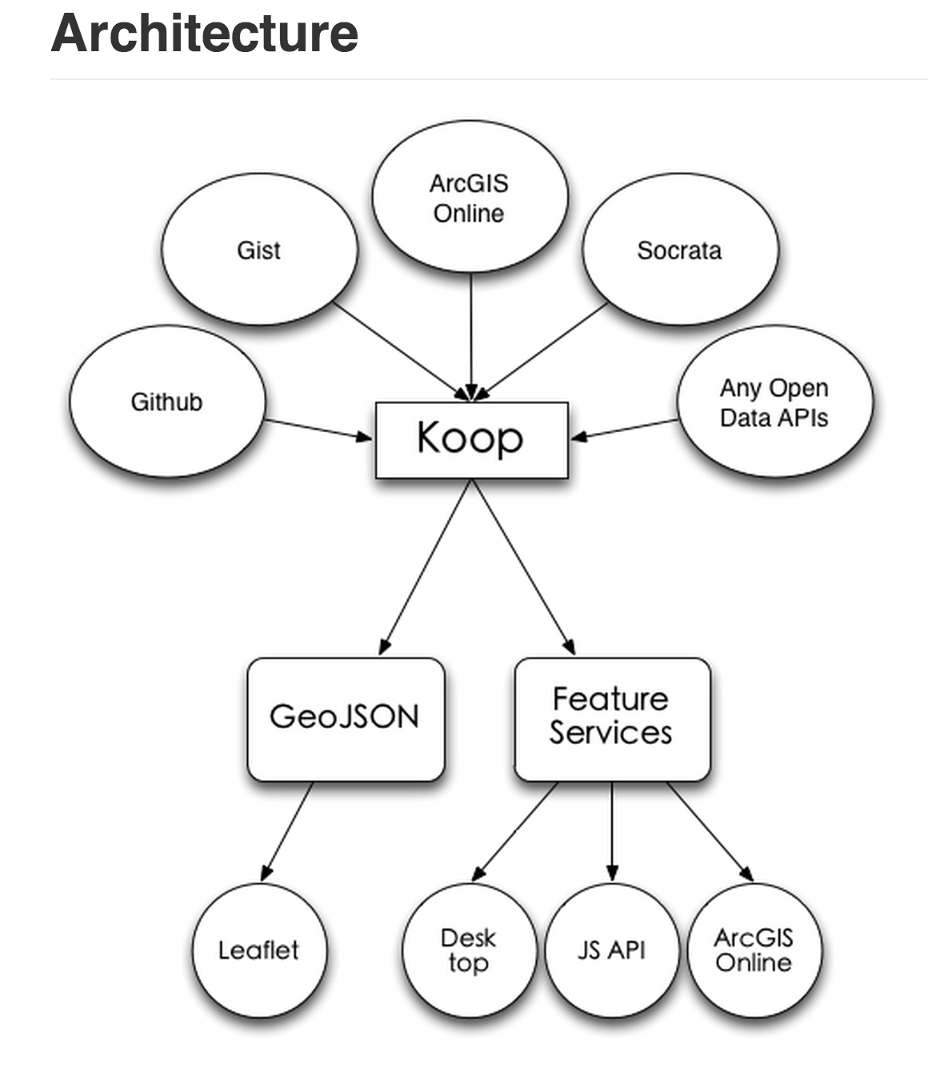
koop
- Open Source (github.com/Esri/koop) R & D
- node js
-
interoperability
- geojson (& others) ==> feature services
- feature services ==> geojson
- export as kml, csv, shp
- tiles for utf grid, png, geojson, & pbf
GeoJSON on github
github.com/colemanm/hurricanes/blob/master/fl_2004_hurricanes.geojsonIn ArcGIS Online map viewer:
www.arcgis.com/home/webmap/viewer.html?url=http://koop.dc.esri.com/github/colemanm/hurricanes/fl_2004_hurricanes/FeatureServer/0Tiles (koop-url/{z}/{x}/{y}.png):
koop.dc.esri.com/github/colemanm/hurricanes/fl_2004_hurricanes/tiles/5/12/14.png.png Tiles in Leaflet.js:
mjuniper.github.io/koop-leaflet/tiles.htmlSocrata?
data.seattle.gov/resource/2tje-83f6.jsonIn ArcGIS Online map viewer:
www.arcgis.com/home/webmap/viewer.html?url=http://koop.dc.esri.com/socrata/seattle/2tje-83f6/FeatureServer/0Registered as an item in ArcGIS Online:
dcdev.maps.arcgis.com/home/item.html?id=ebf151a0feda4c57ac7422dcd48d87dcAnalysis in ArcGIS Online:
dcdev.maps.arcgis.com/home/webmap/viewer.html?webmap=0dc8c9ecb6be4a329579710cad65440cArcGIS Online Item
dcdev.maps.arcgis.com/home/item.html?id=1dd1c8ccd54347f1bbd966337bde45f7GeoJSON Tiles In Leaflet.js:
mjuniper.github.io/koop-leaflet/Wind.js *
github.com/esri/wind-jsesri.github.io/wind-js/
* based on github.com/cambecc/earth